
The Sagebrush Rabbit Hole—Scouting the Sierra Camino


Sand. It's unpredictable. After a rain, it can be nice and firm and easy riding, but once it's really dry, or has seen a bit of traffic it can start to get thick and harder to pedal through. It seems to be a patchwork of firm ground versus thick sand out there, so hopefully there will be a way to find the best route possible for that section.

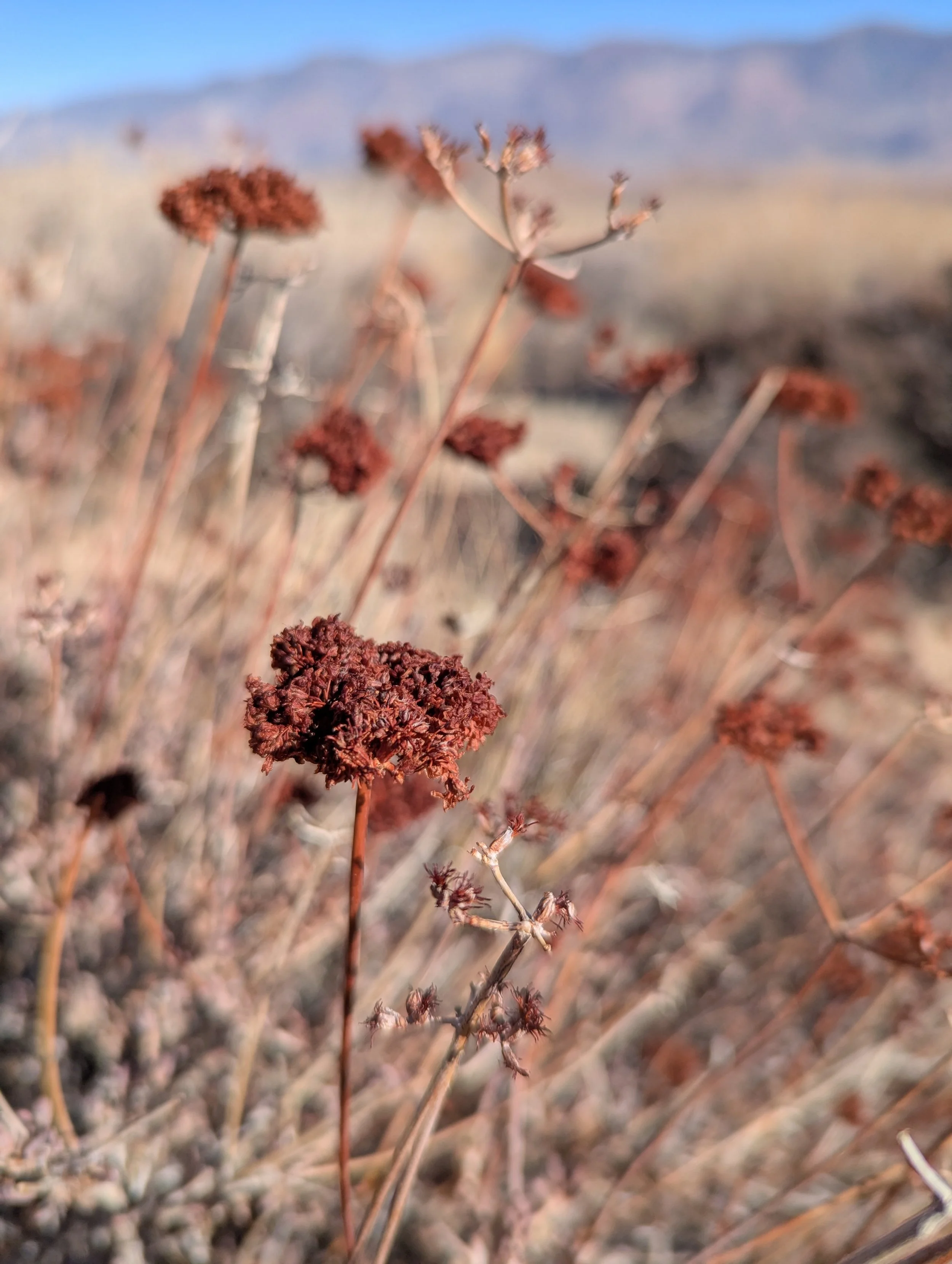
Can these abrupt vegetation differences help us identify soil that’s better for riding?
If only a map of soil conditions existed...is this a thing geologists are into and might actually exist?! There was a point on the singletrack where the different vegetation had such a stark contrast line I stopped to take a photo. I wonder if something like this vegetation mapping (summary) could be helpful, if we could identify what tends to grow on hardpack vs thick sand?! Someone out there must know the answer to this.
According to the vegetation map, this seems to be rabbitbrush (right side) and blackbrush, which *may* have coincided with some different packed sand in our sample size of one. I'm absolutely being an armchair biologist/geologist, so this may have absolutely no validity or use, but wouldn't that be cool if it did?!
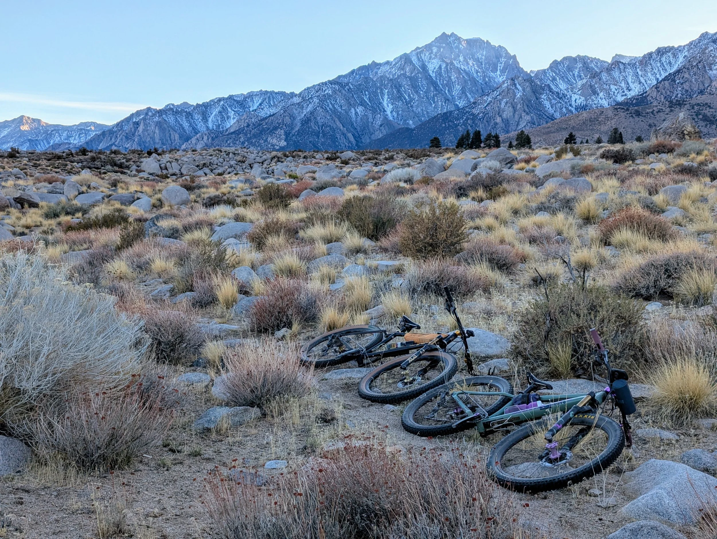
Ana Pimsler and Adam Havner have been out scouting various sections of the Sierra Camino, roughly paralleling Highway 395 on the east side of the Sierra. And as they pushed their bikes through some especially deep sandy washes they began to wonder if there was some way to identify loose sand from satellite imagery. Keep reading for the rest of their scout report.
Who are you and where do you call home? What’s your favorite backcountry trail close to home?
My name is Ana Pimsler, and my partner is Adam Havner. It is rare that we are not riding together, so most of these experiences are from both of us. I am a high school math teacher in Santa Rosa, CA. Adam is an engineer. We have the best riding right out our back door at Annadel State Park, but our favorite backcountry trail has to be anything off of Oat Hill Mine Rd in Napa. The ridges of the Mayacamas are where we go when we want a long day of hiking with our bikes.
What drew you to Orogenesis?
A few years ago we did most of the Oregon Timber Trail as a 19 day bikepacking trip. Because of some fire closures, we made it more of a figure 8 through Oakridge, utilizing other trails and fire roads to make some loops, but the Timber Trail was some of the best riding we've ever encountered on a bikepacking trip, and the fact that so much of it is continuous singletrack is just incredible. We were excited to learn about the Orogenesis project, and that it would be coming through California in areas that are closer to home for us. Connecting areas that have existing trails that people may not usually connect is one of my favorite types of rides, and Orogenesis is just that on steroids.
What area did you scout?
Recently we scouted a section in Owen's Valley, CA between Independence and Lone Pine.
What stood out about this landscape? What do you think people will enjoy most about riding this section?
The views of the Eastern Sierra are absolutely mind blowing every time I enter that valley. the photo-worthy spots are endless, and there were a ton of new plants and animal tracks to discover. If you're a geology nerd, get your lens ready.
Did you find any secret connections, or other gems for the route? Any tips for future riders?
The singletrack out of Independence is a gem for sure. Very mellow, but again with the stunning views, and just a fun out and back, or loop if you use the fire road up. The Alabama Hills Cafe is a must stop in Lone Pine for breakfast.
What will be the biggest challenges for people riding this section?
Sand. It's unpredictable. After a rain, it can be nice and firm and easy riding, but once it's really dry, or has seen a bit of traffic it can start to get thick and harder to pedal through. It seems to be a patchwork of firm ground versus thick sand out there, so hopefully there will be a way to find the best route possible for that section. Also sun exposure. There's very little shade through that whole valley, so be prepared to be exposed to the elements for much of the Eastern Sierra section.
I noticed an area that had a stark defining line between two vegetation types, and that lead me to wondering if that was information that could be used to look for the harder pack ground versus the deep sand? Like, if a plant likes the harder pack, then could we just look for where that plant grows and assume maybe that will be better trail building ground? I have yet to prove this theory, nor the background to go much farther than wonder, but maybe this will spark an idea for somewhere out there reading this!
How do you think we can improve this section for riders?
Since the track here isn't finalized, simply creating a north-south singletrack will be an incredible bonus! Currently to traverse that area you have to utilize a lot of fire roads, which are fine, but connecting them requires many east-west traverses, and in that valley that also means losing and gaining about 1,000 feet of elevation every time. It can turn into a lot of unnecessary climbing. The north-south singletrack would alleviate that.
What area would you like to ride/scout next along the route?
We would definitely like to finish what we didn't get to on this section, but also love spending time in the Downieville/Lost Sierra area in the summers, so we'd be interested in helping with anything up that way, too.
Interested in scouting some of the route yourself? In 2024 we scouted over 400 miles of trails but there are still 157 trail miles of unknown condition along the route. We’re working on tools to make it easier, but in the meantime email us and we can point you in the right direction.